-
About Upazila
Introduce to Upazila
History & Tradition
Geography & Economics
Others
-
About Upzila
Upazila Parishad
Information regarding performance appraisal
Information regarding performance appraisal (2)
-
Minutes of Upazila Committee meeting
- Committee on Law and Order
- Development of communication and physical infrastructure
- Agriculture and Irrigation
- Secondary and Madrasa Education
- প্রাথমিক ও গণশিক্ষা
- Health and Family Welfare
- Youth and Sports Development
- Women and Child Development
- Social service
- Freedom fighter
- Fisheries and Livestock
- Rural Development and Cooperatives
- Culture
- Forests and environment
- Market price observation, monitoring and regulation
- Finance, budgeting, planning and local resource mobilization
- Public health, sanitation and clean drinking water supply
-
Minutes of Upazila Committee meeting
-
About Upazila Administration
Upazilla Nirbahi Officer
About Organogram
Schedule & Meeting
- Municipality
-
Govt. Offices
Security & Discipline
Education & Culture Related
Agriculture, Fisheries, Livestock & Food
Health & Environment Related
Land & Revenue Related
Engineering & ICT
Human Resource Development Related
-
Different Institutions
Educational Institutions
Non-Govt. Organizations
- E-Service
- Gallery
- COVID-19
-
About Upazila
Introduce to Upazila
History & Tradition
Geography & Economics
Others
-
About Upzila
Upazila Parishad
Information regarding performance appraisal
Information regarding performance appraisal (2)
-
About Upazila Administration
Upazilla Nirbahi Officer
About Organogram
Schedule & Meeting
- Municipality
-
Govt. Offices
Security & Discipline
Education & Culture Related
Agriculture, Fisheries, Livestock & Food
Health & Environment Related
Land & Revenue Related
Engineering & ICT
Human Resource Development Related
-
Different Institutions
Educational Institutions
Non-Govt. Organizations
- E-Service
- Gallery
-
COVID-19
31-point directive of Hon\'ble Prime Minister on the current situation of Corona Viral Disease (COVID-19)
Covid-19 Prevention and Remedy Guidelines
The area of Raipur upazila of Lakshmipur district is 195.98 square km. It has Faridganj and Ramganj upazilas to the north, Sadar upazila to the east, Mehendiganj upazila of Barisal to the south, Hijla and Hamchar upazilas to the west and Meghna river. Its main rivers are Meghna and Dakatiya.
2. Raipur at a glance
(a) Boundaries : Haimchar and Faridganj upazilas of Chandpur district on the north, Ramganj and Laxmipur Sadar upazilas on the east, Meghnadi and Hijla upazilas of Barisal district on the west and Lakshmipur Sadar upazila on the south.
(b) Area : 195.98 square kilometers.
(c) Location : 22.53° and 23.04° north latitude and 90.38° and 90.50° south latitude.
(d) Topography: Mostly flat land.
(e) Notable rivers: Meghna and Dakatiya rivers.
(f) Forestry: Beri dam afforestation and road and road renewal link road afforestation.
3. Demographic Information : (a) Population 3,13,659 people
(b) Education Rate: 70.7%
(c) Disability Rate: 6.8%
Source: According to Census and House Census 2022
4. Number and Name of Municipality and Union:
Municipalities- 01 and Union 10.
Order Municipality/Union Name Population Size
01 Raipur Municipality 39,809 people 10.02 square kilometers
02 No. 1 North Char Ababil Union 28,973 people 13.69 square kilometers
03 No. 2 North Char Banshi Union 40,628 people 48.88 square kilometers
04 No. 3 Char Mohana Union 27,953 people 24.22 square kilometers
05 No. 4 Sonapur Union 26,200 people 09.34 square kilometers
06 No. 5 Charpata Union 16,366 people 07.83 square kilometers
07 No. 6 Keroa Union 33,974 people 16.75 square kilometers
08 No. 7 Bamani Union 28,822 people 13.98 square kilometers
09 No. 8 South Char Banshi Union 33,206 people 28.28 square kilometers
10 No. 9 South Char Ababil Union 26,601 people 16.30 square kilometers
11 No. 10 Raipur Union 11,127 people 06.67 square kilometers
Source: According to Census and House Census 2022
5. Number of Educational Institutions:
(a) Colleges: (1) Government-1, (2) Private-4, (3) Schools and Colleges (Joint)-1.
(b) High schools - 32, Madrasas - 22.
(c) Primary Schools: (1) Government- 121, (2) Private- 21, (3) Kinder Gate- 65, (4) Sub-formal Schools-79, (5) NGO Schools- 04.
6. Financial Institutions: (a) Banks-18, (b) Insurance-07, (c) Multi-Purpose-04.
7. Religious institutions: (a) Mosques-550, (b) Temples-20, (c) Churches- none, (d) Orphanages-07.
8. Number of expatriates: No.
9. Prominent personalities: (a) Honorable Members of Parliament: 1st- Mr. Mohammad Ulya, 2nd- Advocate Ismail Hossain, 3rd- Mr. Md. Khorshed Alam Chowdhury, 4th and 5th Mr. Mohammad Ulya, 6th- 15 Feb/96 Mr. Abul Khair Bhuiyan, 7th- Begum Khaleda Zia, by-election Mr. Haroon-Or Rashid, 8th- Begum Khaleda Zia, by-election Mr. Abul Khair Bhuiyan, 9th- Mr. Abul Khair Bhuiyan.
10. Present Honorable Member of Parliament: Advocate Nooruddin Chowdhury Nayan, Laxmipur-2 (Sadar & Raipur)
11. Current Upazila Parishad
(a) Current Upazila Chairman: Principal Mamunur Rashid
(b) Current Vice Chairman Group: (1) Advocate ABM Barakat Bin Zakaria (Recognized) (2) Hasina Akter
12. Current Mayor: Mr. Md Ghiyas Uddin Rubel Bhat
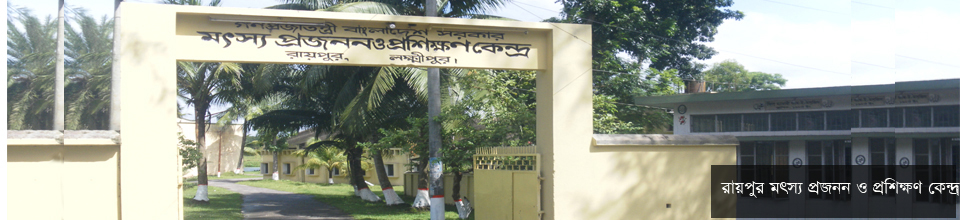
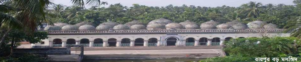
13. Historical Places: (1) Fish Breeding and Training Center (2) Haji Mara Switch Gate (3) Jinn Mosque.
14. Communication system:
(1) Paved road- 320.11 km
(2) Semi-paved road- 31.67 km
(3) Unpaved road- 1154.26 km,
(4) Road over embankment - 23.23 km.
(5) Bridge- 10
(6) Bailey Bridge- 01
(7) Kalbhat- 508


Planning and Implementation: Cabinet Division, A2I, BCC, DoICT and BASIS
Technical Assistance:
![]()
Developed By:
